| Photos From Wyoming Tales and Trails This page: Worland, Ten Sleep, Greybull |
 |
|
| Photos From Wyoming Tales and Trails This page: Worland, Ten Sleep, Greybull |
|
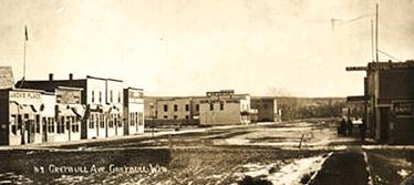 Greybull, 1900 Greybull is allegedly named after an albino American Bison. Maps prepared by John C. Fremont's Expeditions, 1842-1845, reflect the existence of the Greybull River and indicate that Fremont ventured into the Basin. Both Kit Carson and Basil Cimineau LaJeunesse acted as guides. The Seminoe [an Anglicized variation of Cimineau] Mountains and Reservoir are named after LaJeunesse. LaJeunesse was killed by Indians in Oregon. As indicated in the discussion of the Bozeman Trail on the Buffalo page, the Bridger Trail passed through the Basin near present day Worland
 Greybull, 1941, photo by Marion Post Wolcott Undated photo of Greybull by W. A. Sode to lower right.
For biographical information as to
Marion Post Wolcott, see Sheridan Page. Greybull and Shell are also noted as being the center of significant
Jurassic and Cretaceous Period dinosaur deposits. In 1933, based on information furnished by
by Mrs. M. L. Austin, an amateur fossil In 1993 and 1994, as a result of a suggestion by Cody resident, Carol Hill, the Smithsonian dispatched its first dinosaur expedition since 1938. This resulted in discovery of additional deposits from both the Jurassic and Cretaceous Periods near Shell. Both Brown and Bird were regarded as colorful. Brown conducted his field work in coat and tie. Bird explored for new deposits on his Harley-Davidson. Bird, self-taught, was the author of Bones for Barnum Brown: Adventures of a Dinosaur Hunter.
Shortly after Wyoming gained territorial status the idea of
an expedition to the Big Horn Basin took root in Cheyenne.
In 1870, over the objections of
President Grant, but with the support
of local military officials an
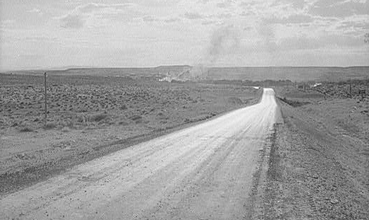
expedition seeking gold proceeded into the Basin. President Grant, Modern view of Ten Sleep, left, compare with 1953 photo below. Ten Sleep allegedly received its name by being a ten days (sleeps) journey from Indian camps on the North Platte near present day Casper and near present day Bridger, Montana, on the Clark Fork. In 1810, merchant Wilson Price Hunt's expedition to Oregon passed near present day Ten Sleep and along the Nowood Valley. As a guide, Hunt proved to be somewhat inept. He attempted a short cut leading the expedition into an area with so little water that even his dog died of thirst. After passing into present day Idaho, he then attempted to raft down the Snake and as a result lost his supplies and equipment. The 1895 U.S. Atlas fails to list Ten Sleep. However, by 1901 the state directory showed it as having a post office and a population of 10. The business directory listed 12 business persons in the area, 11 stock growers and the postmaster, Martha Bull. The Town was incorporated in 1933. 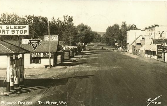 Ten Sleep, 1953
On July 4, 1874, an expedition led by Capt. Elliott Bates of the 2nd U.S. Cavalry
accompanied by 167 Shosone under Chief Washakie and 20 scouts unter Lt. R. H. Young of the
4th Infantry located "hostiles" in a Big Horn County began to be settled in the 1870's. Henry Clay Lovell, after whom Lovell, Wyoming is named, in partnership with Anthony L. Mason of Kansas City, brought the cattle industry to the area with the establishment of a ranch at the mouth of Nowood Creek, followed by the establishment the following year of a second ranch on Shell Creek. A third ranch was formed at Five Springs which became the headquarters for the operation. At one time the partnership controlled 25,000 head ranging from Thermopolis north into Montana. Other settlers in the area included Josia Cook, first postmaster for Lovell and B. F. Wickwire who homesteaded Medicine Lodge
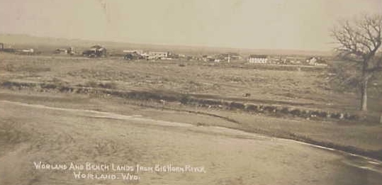 Worland, Wyo. and Big Horn Rivr
The northern part of the basin was settled by L.D.S. at the beginning of the
1900's, without financial assistance by
either the government Worland was named after Charlie Worland, the manager of a stage station. Worland pictured before the 1907 fire to the upper right, was originally settled in 1903 and was referred to as "Camp Worland." by 1906 the Railroad had arrived, but, unfortunately, on the east side of the Big Horn River while the town was on the west side. Following the example of the Prophet Mohammed, that if the mountain will not come to Mohammed, Mohammed will go to the mountain, the town was moved to the opposite side of the river. Big Horn Basin continued on next page, Thermopolis and Meeteetse. |


 collector, Barnum Brown (1873-1963),
uncovered a bone deposit on the Barker Howe Ranch near the base of the Bighorn Mountains.
The following year, with financial support from the Sinclair Refining Company, Brown with
Roland Thaxter Bird (1899-1978) returned to the site which proved to be one of the
most significant beds of Sauropods in the world. As a result, Sinclair adopted
the Dinosaur as its trademark. Dr. Brown developed a hypothosis
that the concentration of bones was as a result of a massive disaster causing
a desiccation of lakes and swamps. More recently, following a ten-year study of the
Howe Ranch site, Kirby
Siber, director of a dinosaur museum in Aathal,
Switzerland, has reiterated
the theory, indicating his belief that the site was caused by "a huge catastrophe" such as
a hurricane, flood or similar natural event.
collector, Barnum Brown (1873-1963),
uncovered a bone deposit on the Barker Howe Ranch near the base of the Bighorn Mountains.
The following year, with financial support from the Sinclair Refining Company, Brown with
Roland Thaxter Bird (1899-1978) returned to the site which proved to be one of the
most significant beds of Sauropods in the world. As a result, Sinclair adopted
the Dinosaur as its trademark. Dr. Brown developed a hypothosis
that the concentration of bones was as a result of a massive disaster causing
a desiccation of lakes and swamps. More recently, following a ten-year study of the
Howe Ranch site, Kirby
Siber, director of a dinosaur museum in Aathal,
Switzerland, has reiterated
the theory, indicating his belief that the site was caused by "a huge catastrophe" such as
a hurricane, flood or similar natural event.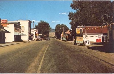 with perhaps some
foresight, feared that the expedition would ultimately lead to unpleasantness with the Indians
who had been guaranteed by treaty reservations on three sides of the Basin.
with perhaps some
foresight, feared that the expedition would ultimately lead to unpleasantness with the Indians
who had been guaranteed by treaty reservations on three sides of the Basin.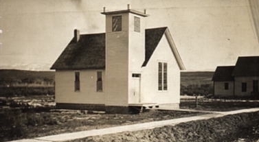 village located 37 miles southeast of present
day Worland. At 7:30 a.m. 35 troopers charged. At the end of 20 to 30 minutes
no adults were left in the village, scores of wounded escaped to rocks on the butte
above the village where returned fire killed two cavalrymen and wounded three.
Indians losses included
29 known dead, although, undoubedly, many others who escaped later died from
their wounds. Memory of that battle beside Bates Creek and the earlier treatment
at Blue Water Creek discussed elsewhere, contributed to Indian reactions leading to
the Battle of the Little Big Horn and the disaster overtaking Geo. A. Custer two years later,
fullfilling Grant's fears.
village located 37 miles southeast of present
day Worland. At 7:30 a.m. 35 troopers charged. At the end of 20 to 30 minutes
no adults were left in the village, scores of wounded escaped to rocks on the butte
above the village where returned fire killed two cavalrymen and wounded three.
Indians losses included
29 known dead, although, undoubedly, many others who escaped later died from
their wounds. Memory of that battle beside Bates Creek and the earlier treatment
at Blue Water Creek discussed elsewhere, contributed to Indian reactions leading to
the Battle of the Little Big Horn and the disaster overtaking Geo. A. Custer two years later,
fullfilling Grant's fears.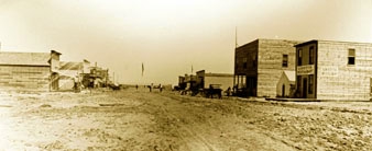 or the Church. Wm. F. Cody, hoping to attract settlers to the area, gave water
rights to the Big Horn Colonization Company, which permitted labor to be
exhanged for shares. The settlers dug the Sidon Canal a distance of 37 miles
from its headgate on the Shoshone in two years,
aided when a large sandstone boulder, now
known as "Prayer Rock", was split by what they regarded as
answered prayers and divine intervention.
or the Church. Wm. F. Cody, hoping to attract settlers to the area, gave water
rights to the Big Horn Colonization Company, which permitted labor to be
exhanged for shares. The settlers dug the Sidon Canal a distance of 37 miles
from its headgate on the Shoshone in two years,
aided when a large sandstone boulder, now
known as "Prayer Rock", was split by what they regarded as
answered prayers and divine intervention.