|
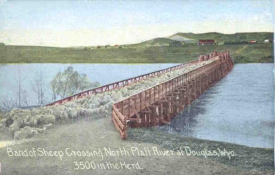
Sheep, Douglas, 1912
As noted on the previous page, settlement in
the Douglas area began in 1867 at Fort Fetterman while Douglas, itself, was established in
1886 with the arrival of the Railroad. Originally known as Tent Town, it was named
Douglas, as was Douglas, Georgia, in recognition of Stephen A. Douglas's
support for the transcontinental railroad. In the Senate, Douglas was responsible for
the extension of the Illinois Central to Chicago, thus, making Chicago the
rail hub on North America.
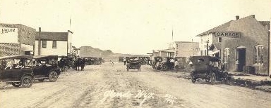 As noted above, Glendo, pictured approximately 1920 to left,
is on the site
of the Horseshoe Station, an early Pony Express and Overland Stage station. The
station was the location of the first telegraph station in the Territory and also
the home station for the Rocky Ridge Division of the Overland Stage and, thus,
the place of residence of Jack Slade (see discussion on
Ghost Towns page with regard to Point of Rocks Station which he robbed).
It was here, in fact, that Slade employed young Billy Cody as a rider. As noted above, Glendo, pictured approximately 1920 to left,
is on the site
of the Horseshoe Station, an early Pony Express and Overland Stage station. The
station was the location of the first telegraph station in the Territory and also
the home station for the Rocky Ridge Division of the Overland Stage and, thus,
the place of residence of Jack Slade (see discussion on
Ghost Towns page with regard to Point of Rocks Station which he robbed).
It was here, in fact, that Slade employed young Billy Cody as a rider.
Sir Richard Burton, the 19th Century British adventurer, in his 1860 log book of his cross-country
stage trip, commented on his overnight stay at Horseshoe Station:
"We were informed that �lady travelers� were admitted into the house, but
the ruder sex must sleep where it could or not sleep at all if it preferred.
We found a barn hardly fit for a decently brought up pig; which had no door
and a damp floor. Into this disreputable hole we were all thrust for the
night even the federal judge amongst us whose position procured him only a
broken down pallet."
Sir Richard Burton August 14, 1860 9:30 PM
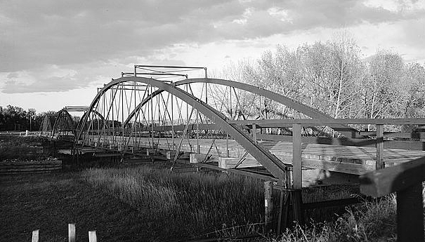
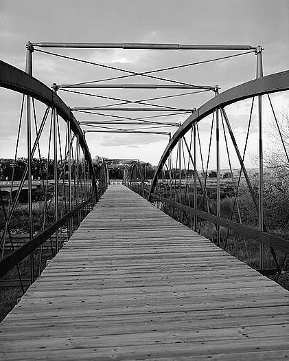
Fort Laramie Military Bridge
Military Bridge photos courtesy Library of Congress, Prints and Photographs Division
The above-view is of the northwest side of
the bridge. Lower photo is looking northwest. By 1873 Cheyenne had become a center for freighting.
 Concern
grew, however, that because of difficulties in crossing the North Platte that
freighting might move to other cities on the Union Pacific that did not have
such difficulties. When Laramie County refused to construct a bridge, the
territory's congressional delegate, William Randolph Steele (1842-1901), secured the support of Secretary of
War Belknap for a bill requiring the military to build a bridge. Orders for
the construction of the bridge were issued the day after President Grant signed the bill.
The Fort Laramie Bridge was constructed by the King Bridge and Manufacturing Co. of
Cleveland, Ohio between July 1875 and February 1876 at a cost of $10,500. The bridge is
the oldest military bridge west of the Mississippi. The last military unit was
withdrawn from Fort Laramie on March 2, 1890. Thereafter in 1894, the bridge was
turned over to Laramie Country. Maintenance assumed by newly-formed Goshen County in 1911. The bridge remained
in use until completion of a new concrete bridge in 1958, visible at the left in the above-left photo. In 1961, the
bridge reverted back to the United States which continues to maintain it under the
United States Park Service. Concern
grew, however, that because of difficulties in crossing the North Platte that
freighting might move to other cities on the Union Pacific that did not have
such difficulties. When Laramie County refused to construct a bridge, the
territory's congressional delegate, William Randolph Steele (1842-1901), secured the support of Secretary of
War Belknap for a bill requiring the military to build a bridge. Orders for
the construction of the bridge were issued the day after President Grant signed the bill.
The Fort Laramie Bridge was constructed by the King Bridge and Manufacturing Co. of
Cleveland, Ohio between July 1875 and February 1876 at a cost of $10,500. The bridge is
the oldest military bridge west of the Mississippi. The last military unit was
withdrawn from Fort Laramie on March 2, 1890. Thereafter in 1894, the bridge was
turned over to Laramie Country. Maintenance assumed by newly-formed Goshen County in 1911. The bridge remained
in use until completion of a new concrete bridge in 1958, visible at the left in the above-left photo. In 1961, the
bridge reverted back to the United States which continues to maintain it under the
United States Park Service.
Steele, a Democrat, served as a captain during the Civil War and was awarded the brevet
rank of Lt. Colonel. A lawyer, he moved to Wyoming in 1869 and served in the
Territorial Legislative Council from 1871 to 1873. until he was elected as concressional
delegate. He was defeated for reelection in 1876. He thereafter moved to Deadwood where he
served as mayor 1894-1896. Upon the formation of South Dakota he declined the Democratic
nomination as congressional delegate.
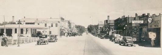
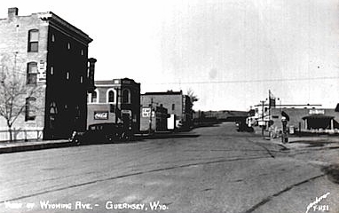 Present day Guernsey is on the site of
"Emigrant's Tub," a place along the Oregon Trail where, in the 1840's, pioneers
would stop to bath and wash their laundry.
Present day Guernsey is on the site of
"Emigrant's Tub," a place along the Oregon Trail where, in the 1840's, pioneers
would stop to bath and wash their laundry. Guernsey, 1930's, right.
One mile south of the town are the
Oregon Trail Ruts where wagon ruts made by the emigrants were literally worn into
the rock. Three miles from town are Register Cliffs where emigrants placed their
names. The earliest, believed to be that of a French trapper, is dated July 14, 1829.
Guernsey, as a town, however dates
only to 1902. It was founded by the Lincoln Land Co., a subsidiary of the Burlington
Railroad and was named after Charles A. Guersey,
a state representative and who owned a ranch at Register Cliffs. The Lincoln Land Co. also founded a number of towns
along the Burlington all across Nebraska as well as Kansas and eastern Colorado, chief among
them Scottsbluff.
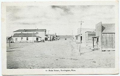
Torrington, 1930's
Compare with earlier photo to lower left. Torrington was founded
by William G. Curtis in 1889, who named it after his hometown in Connecticut. Curtis was
also the first postmaster, maintaining the post office at his homestead.
 Torrington, undated, photo by H. Yoder
H. Yoder is believed to refer to Hiram W. "Hi" Yoder. Yoder conducted the band at the
laying of the cornerstone for the Goshen County Courthouse in 1913. By that time
motor cars had arrived, with the first cars being owned by Dr. C. H. Platz, J. T.
Snow and Joe Amery. In 1913, J. P. Nolan owner of a local garage ran an advertisement in
the Torrington Telegram advising persons not to "ruin" the automobiles in his garage by
striking matches on the paint.
The Burlington began passenger service in May 1900, with George King serving as
station agent.
See 1913 view of railway station, water tank and
coal chutes lower right. The Town was incorporated in
1906 with Curtis being elected as the first mayor. Curtis also served one term
in the state legislature. By 1910 the town had a population of 155. With the town becoming
the county seat in a hotly contested election with Lingle, five years later population had almost tripled to 443. Between Torrington and Lingle
was the Texas Trail along which cattle were brought from Texas to Northern Wyoming
and Montana. 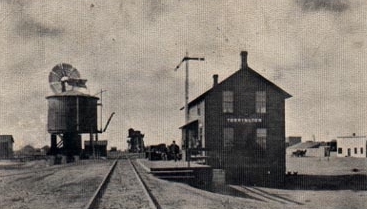 Torrington railway station, 1913
Goshen County is, apparently, not named after
the biblical land of Goshen. Instead, the area on the Nebraska-Wyoming border along the
North Platte was originally named Goshe's Hole.
John C. Frement reported that his expedition camped on
July 14, 1842 in what he supposed was Goshen's Hole. By the turn of the century the valley
had become Goshen Hole, which name is still used with reference to the Goshen Hole Reservoir
south of Yoder and the Goshen Hole Ditch to the east of Yoder. The 1895 Atlas
of Wyoming reflects the existence of a town named Goshen on the west side of
Horse Creek. The Atlas while indicating the presence of a post office also failed
to show any population.
|